
Description
Book Synopsis:
- • Waterproof
- • Tear-Resistant
- • Topographic Map
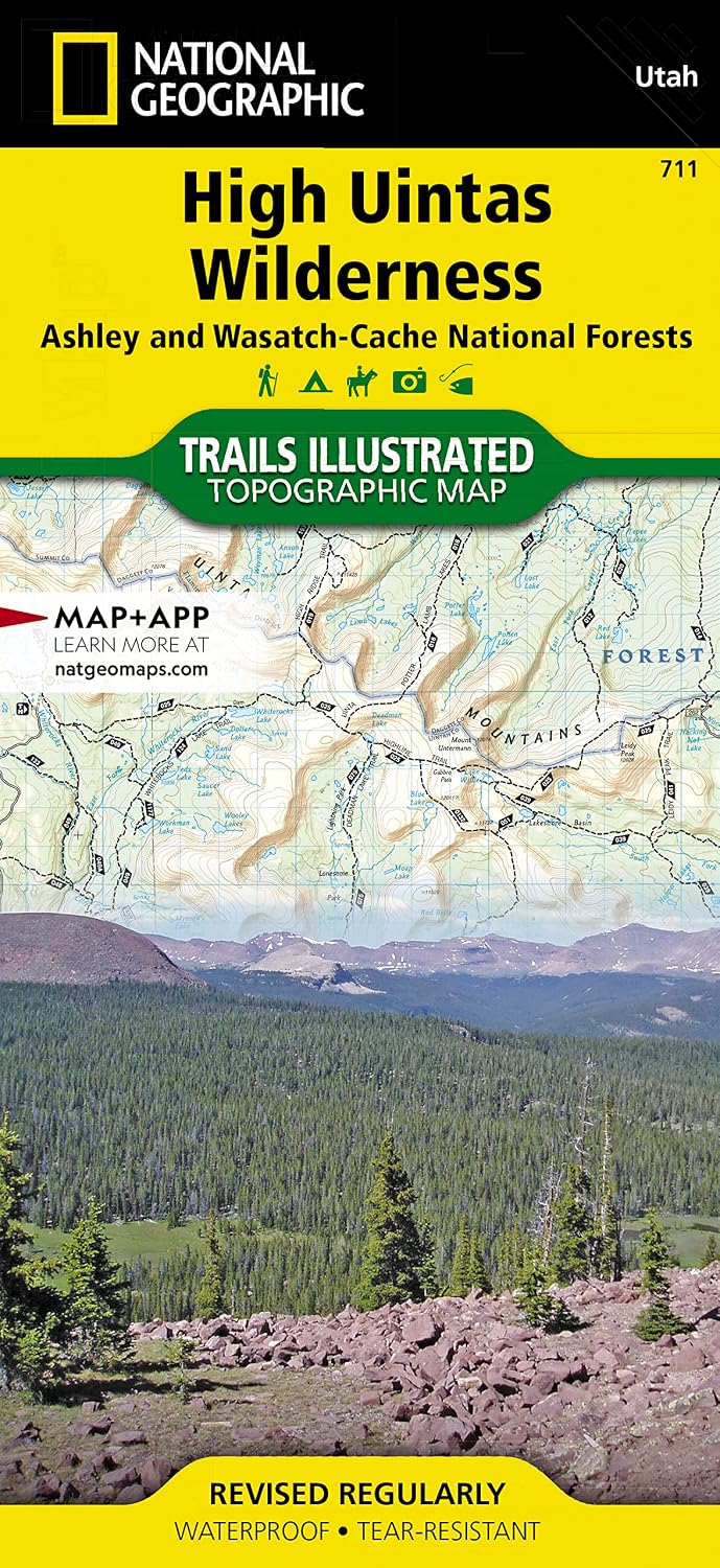
Explore the alpine vistas, glacier-formed lakes, and Utah's highest peaks with National Geographic's Trails Illustrated map of High Uintas Wilderness, Ashley and Wasatch-Cache National Forests. Expertly researched and created in partnership with local land management agencies, this map features key points of interest including Mirror Lake, Kings Peak, Sheep Creek Canyon Geological Area, and portions of the Yellowstone, Uinta, and Duchesne rivers.
With hundreds of miles of mapped trails, the High Uintas Wilderness map can guide you off the beaten path and back again. A handy chart notes each trailhead, the number of parking spaces at the trailhead, and the facilities available there including horse ramps, corrals, water, toilets, and developed campsites. Snowmobile and ATV trails, as well as four-wheel-drive and high clearance roads are clearly marked. The map base includes contour lines and elevations for summits, passes and many lakes. Helpful information about regulations and wilderness safety is included to help ensure your visit is safe and enjoyable.
Every Trails Illustrated map is printed on "Backcountry Tough" waterproof, tear-resistant paper. A full UTM grid is printed on the map to aid with GPS navigation.
Other features found on this map include: Ashley National Forest, High Uintas Wilderness, Kings Peak, Marsh Peak, Mount Lovenia, Uinta National Forest, Wasatch National Forest.
Map Scale = 1:75,000
Sheet Size = 37.75" x 25.5"
Folded Size = 4.25" x 9.25"
Details
Explore the breathtaking beauty of the High Uintas Wilderness, Ashley and Wasatch-Cache National Forests with National Geographic's Trails Illustrated Waterproof Map Book. This map offers an extensive coverage of the alpine vistas, glacier-formed lakes, and Utah's highest peaks, providing you with a comprehensive guide to this stunning wilderness. Expertly researched and created in partnership with local land management agencies, this map guarantees accuracy and reliability for all outdoor enthusiasts.
Featuring hundreds of miles of mapped trails, the High Uintas Wilderness Map Book allows you to venture off the beaten path and discover hidden gems in this pristine natural landscape. With a handy chart detailing each trailhead, parking facilities, and camping options, you will have all the information you need for a successful excursion. Whether you're an avid hiker, biker, or camper, this map book ensures a memorable and well-prepared adventure.
Not only does the High Uintas Wilderness Map Book cover hiking trails, but it also includes marked snowmobile and ATV trails, as well as four-wheel-drive and high clearance roads. No matter your mode of transportation, this map book has you covered. With contour lines and elevations for summits, passes, and lakes, you'll have a complete understanding of the topography and terrain.
Designed to withstand the toughest outdoor conditions, every Trails Illustrated map is printed on "Backcountry Tough" waterproof and tear-resistant paper. You can trust that this map will endure any weather or adventure, ensuring its longevity and usability for countless trips to come. Additionally, the inclusion of a full UTM grid aids with GPS navigation, taking your outdoor experience to a new level of convenience and accuracy.
Experience the wonders of the High Uintas Wilderness like never before with the Trails Illustrated Waterproof Map Book. Plan your next hiking, camping, or biking trip with confidence and precision. Get your hands on the ultimate guide to this remarkable wilderness today.
Discover the High Uintas Wilderness Map Book and unlock the gateway to unforgettable adventures.
Discover More Best Sellers in Nature Travel
Shop Nature Travel
Draw Your Adventures: Making Art to Celebrate Everyday Experiences and Travels Near and Far
 Nature Travel - Draw Your Adventures: Making Art to Celebrate Everyday Experiences and Travels Near and Far

Joy Ride: A Bike Odyssey from Alaska to Argentina
Nature Travel - Joy Ride: A Bike Odyssey from Alaska to Argentina

Day Hikes in Washington State: 90 Favorite Trails, Loops, and Summit Scrambles
 Nature Travel - Day Hikes in Washington State: 90 Favorite Trails, Loops, and Summit Scrambles
![Nature Travel - Pisgah Ranger District Map [Pisgah National Forest] (National Geographic Trails Illustrated Map, 780)](https://images-na.ssl-images-amazon.com/images/I/91PtDD4w2pL._AC_SL1500_.jpg) Nature Travel - Pisgah Ranger District Map [Pisgah National Forest] (National Geographic Trails Illustrated Map, 780)
Nature Travel - Pisgah Ranger District Map [Pisgah National Forest] (National Geographic Trails Illustrated Map, 780)

Europe Map (National Geographic Adventure Map, 3328)
Nature Travel - Europe Map (National Geographic Adventure Map, 3328)


Guide to California Backroads & 4-Wheel Drive Trails (FunTreks Guidebooks)
Nature Travel - Guide to California Backroads & 4-Wheel Drive Trails (FunTreks Guidebooks)