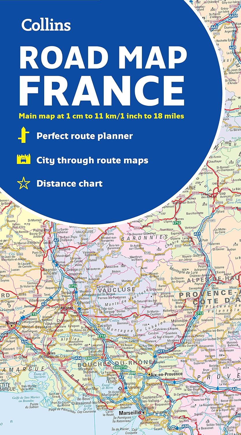

Description
Book Synopsis: A fully revised and updated color road map of France at 18 miles to 1 inch / 11km to 1cm (1:1,120,000). The map shows individual department by name. All cities, towns, roads, European route numbers, motorways and toll motorways are clearly shown, making it the ideal map for planning and route-finding. The map shows the road network in detail for easy route planning. With its political coloring of departments, it is ideal for reference and business users also.
Main features:
- Fully revised and updated
- Clear, detailed road network
- Through-route maps of Paris, Lyon, Marseille, Strasbourg, and Toulouse
- Distance chart giving distances in kilometers between main towns
- Key to department names and numbers, and list of regions
- Internet links to further information
- Full Index to place names
- Map key in English, French, and German.
Covers the whole of France from the Belgian and German borders in the north to the Spanish border in the south, and from the Brest Peninsula in the west to the Italian and Swiss borders in the east. Also includes the island of Corsica.
Details
Are you planning a trip to France? Look no further! The Collins Map of France is the perfect companion for your journey. With its fully revised and updated road map, you'll have all the information you need to navigate the beautiful French countryside. Whether you're traveling for business or pleasure, this map will ensure that you never get lost along the way.
One of the standout features of this map is its clear and detailed road network. All cities, towns, roads, European route numbers, motorways, and toll motorways are clearly shown, making it easy for you to plan your route and find your way around. No more confusion or wrong turns – this map guarantees a smooth and stress-free journey.
But that's not all! The Collins Map of France also includes through-route maps of Paris, Lyon, Marseille, Strasbourg, and Toulouse, allowing you to navigate these bustling cities with ease. Additionally, a distance chart provides you with the exact distances in kilometers between main towns, giving you a clear idea of how long your journey will take.
With its political coloring of departments, this map is not only practical but also a great reference tool for business users. And if you're a history buff or simply curious about the regions you're passing through, internet links to further information are provided. Explore the rich cultural heritage of France as you travel from one place to another.
Don't miss out on this essential travel companion for exploring France. The Collins Map of France covers the entire country, from the Belgian and German borders in the north to the Spanish border in the south, and from the Brest Peninsula in the west to the Italian and Swiss borders in the east. It even includes the beautiful island of Corsica. Start planning your French adventure today with the help of this comprehensive map!
Get your Collins Map of France now and embark on a journey of discovery!
Discover More Best Sellers in Atlases & Maps
Shop Atlases & Maps
DK Eyewitness Top 10 Malta and Gozo (Pocket Travel Guide)
 Atlases & Maps - DK Eyewitness Top 10 Malta and Gozo (Pocket Travel Guide)

Rand McNally Easy To Read: Indiana State Map
Atlases & Maps - Rand McNally Easy To Read: Indiana State Map

Rand McNally Easy To Fold: Missouri State Laminated Map
Atlases & Maps - Rand McNally Easy To Fold: Missouri State Laminated Map

Thomas Guide: San Diego County Street Guide 61st Edition (English and Spanish Edition)
 Atlases & Maps - Thomas Guide: San Diego County Street Guide 61st Edition (English and Spanish Edition)

Thailand Map (National Geographic Adventure Map, 3006)
Atlases & Maps - Thailand Map (National Geographic Adventure Map, 3006)

Chile Map (National Geographic Adventure Map, 3402)
Atlases & Maps - Chile Map (National Geographic Adventure Map, 3402)

Alaska Map (National Geographic Adventure Map, 3117)
Atlases & Maps - Alaska Map (National Geographic Adventure Map, 3117)

Paris Map (National Geographic Destination City Map)
Atlases & Maps - Paris Map (National Geographic Destination City Map)
![Atlases & Maps - Appalachian Trail: Georgia, North Carolina, Tennessee [Map Pack Bundle] (National Geographic Trails Illustrated Map)](https://images-na.ssl-images-amazon.com/images/I/910elKtNUiL._AC_SL1500_.jpg)

